Mississippi River Corridor Critical Area
Background
 The Mississippi River Corridor and Critical Area (MRCCA) encompasses land along the river within the Twin Cities Metropolitan Area including Fridley. The MRCCA was designated as a state critical area in 1976 in recognition of the river's natural, cultural, and scenic value. Accompanying this designation are specific zoning regulations to guide redevelopment in a manner that balances growth alongside protection of the river's resources. As the local government unit, the City of Fridley is responsible for implementing these zoning regulations within its boundaries. The MRCCA in Fridley includes all properties west of East River Road.
MRCCA Regulations
The City administers the MRCCA zoning standards as an overlay district which guides construction of new structures, facilities, and impervious surface; land alteration; and, vegetation management. New MRCCA rules were adopted starting August 11, 2023. If your property is in the Critical Area, please read on to determine if your project needs a Critical Area permit. To apply for a permit, please apply through CitizenServe, the City's online permitting portal.
MRCCA Zoning Standards for Your Property
Is my property in the MRCCA?
The MRCCA in Fridley encompasses all properties west of East River Road. Within the MRCCA, there are different districts which have unique zoning regulations. You can check if you are in the MRCCA and which district you are in using the MRCCA District Map.
Does my project need a permit?
Any work that requires a building permit or other City permit requires those permits in the Critical Area. A permit is also needed to:
- Construct any structures, impervious surfaces, or facilities on a property with frontage along the Mississippi River, frontage along a natural drainage route, or with a bluff that is not already subject to a building permit
- Perform any intensive vegetation clearing (removal of contiguous trees or shrubs) within a primary conservation area as described below
- Perform any land alteration within the bluff impact zone or water quality impact zone described below
Permits are not needed to maintain existing lawns or gardens or repair existing riprap or retaining walls. A permit is needed for construction of new riprap and retaining walls.
How do I apply for a Critical Area permit?
The Critical Area permit application is available through the CitizenServe Portal.
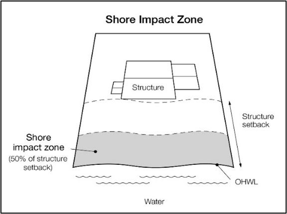
What are the setbacks for structures, impervious surfaces, and facilities in the MRCCA?
Setbacks in the MRCCA are dependent on the Critical Area District. Maps are available showing the district boundaries and primary conservation areas including bluffs.
| Measurement |
Separated from River District |
River Neighborhood District |
Urban Mixed District |
| Height |
Underlying Zoning |
35 feet |
65 feet |
| Setback from Bluff |
40 feet |
40 feet |
40 feet |
| Setback from River |
NA |
100 feet |
50 feet |
| Setback from Tributary |
50 feet |
50 feet |
NA |
There are some exceptions to the setbacks listed above. Legally nonconforming principal structures that do not meet the setback requirements may be expanded laterally provided that:
- The expansion does not extend into the shore or bluff impact zone or further into the required setback than the building line of the existing principal structure.
- The expanded structure’s scale and bulk is consistent with that of the original structure and existing surrounding development.
Decks and at-grade patios may encroach into the required setbacks from the ordinary high water level and blufflines without a variance, provided that:
- The deck or patio does not extend into the bluff impact zone.
- The encroachment of the deck or patio into the required setback area does not exceed 15% of the required structure setback
- The area of the deck or patio that extends into the required setback area occupies no more than 25% of the total area between the required setback and the 15% using the formula:
Required setback depth (feet) x 0.15 x lot width at setback (feet) x 0.25 = maximum total area.
A water-oriented accessory structure is a small building or other improvement, except stairways, fences, docks, and retaining walls, that, because of the relationship of its use to public waters, needs to be located closer to public waters than the normal structure setback. Examples include gazebos, screen houses and detached decks and patios. One water-oriented accessory structure is allowed for each riparian lot or parcel less than 300 feet in width at the ordinary high water level, with one additional water-oriented accessory structure allowed for each additional 300 feet of shoreline on the same lot or parcel. Water-oriented accessory structures must
- Not exceed 12 feet in height;
- Not exceed 120 square feet in area;
- Be placed a minimum of ten feet from the ordinary high water level
- Not be placed within the bluff impact zone
What are the standards for access paths and stairways to the river?
Stairways, paths, and landings must meet the following standards:
- Paths to the river must be no more than eight feet wide in the shore impact zone or four feet wide in the bluff impact zone.
- Stairways to the river must be no wider than four feet in width.
- Landings for stairways must not exceed 32 square feet.
- Canopies are not allowed on stairways or landings.
- Stairways and landings must be located in the least visible portion of the lot whenever practical.
- Ramps, lifts, or mobility paths for person with physical disabilities not meeting these standards are allowed with an administrative permit.
What are the standards for vegetation clearing in the MRCCA?
Maintaining vegetative cover along the river is important to maintain the river's ecological health, habitat, and viewshed. If you are planning to perform intensive vegetation clearing (removal of trees or shrubs in a contiguous path, strip, row, or block) within a:
- Shore impact zone
- Bluff impact zone
- Water quality impact zone
- Area of native plant community
- Mapped significant vegetative stand
You will need to apply for a permit. A permit may only be approved in the following circumstances:
- Clearing of vegetation that is dead, diseased, dying, or hazardous
- Clearing to prevent the spread of diseases or insect pests
- Clearing to remove invasive non-native species
- Clearing for habitat restoration and erosion control management activities consistent with an approved plan
- The minimum necessary for development with an approved permit or as an exemption under the MRCCA code
A permit is not needed in the following scenarios:
- Maintenance of existing lawns, landscaping, and gardens
- Removal of vegetation in emergency situations as determined by the City
- Right-of-way maintenance for public facilities meeting the standards of the MRCCA Code
- Selective vegetation removal of trees provided that vegetative cover as viewed from the river remains consistent with the management purpose of the MRCCA district
All trees greater than four inches diameter at breast height that are removed from a primary conservation area listed above must be replaced on a 1:1 ratio by September 30 of the following year, even if a permit is not required. An exception to the tree replacement requirement is for trees removed under a permit for habitat restoration or erosion control with an approved restoration plan.
Vegetation Permit Property Owner Guide(PDF, 1MB)
What are the standards for land alteration in the MRCCA?
If your project is causing land disturbance within the bluff impact zone or the Water Quality Impact Zone (50 feet from the ordinary high water line or edge of the river, a Natural Drainage route or wetland) you may need a permit. This includes installation or replacement of riprap, retaining walls, and other erosion control structures.
Land Alteration Permit Property Owner Guide(PDF, 297KB)
Grading permits are required anywhere in the city for projects moving more than 50 cubic yards of material.
What are the standards for lighting along the river?
Preserving dark skies along the river is important to maintaining the character of the MRCCA. Light pollution disrupts ecosystems and adversely affects wildlife safety. Within the Shore impact zone (50 feet from the river in the River Neighborhood district and 25 feet from the river in the Urban Mixed district), lighting shall be fully shielded and directed away from the river and uplighting is prohibited.
The International Dark Sky Association provides example of recommended lighting(PDF, 653KB) as well as a searchable database of retailers.
What if my existing property does not meet the new rules?
Projects existing prior to the adoption of the new code that met the standards of the old code are considered legally nonconforming and are allowed to continue. You can find more information on legal nonconformities within the zoning chapters of the City Code.
What if my project is below the ordinary high water line of the river?
All projects below the ordinary highwater line of the river must receive approval from the Minnesota Department of Natural Resources (DNR) prior to receiving approval from the City. Please contact the Area Hydrologist, Wes Saunders-Pearce at 651-259-5822 or wes.saunders-pearce@state.mn.us.
Primary Conservation Areas
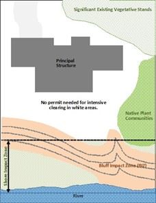
Special zoning regulations within the MRCCA impact properties where primary conservation areas exist. These are most commonly properties along the river or where there are steep slopes (bluffs). In determining if you will need a Critical Area permit, the following definitions may be helpful:
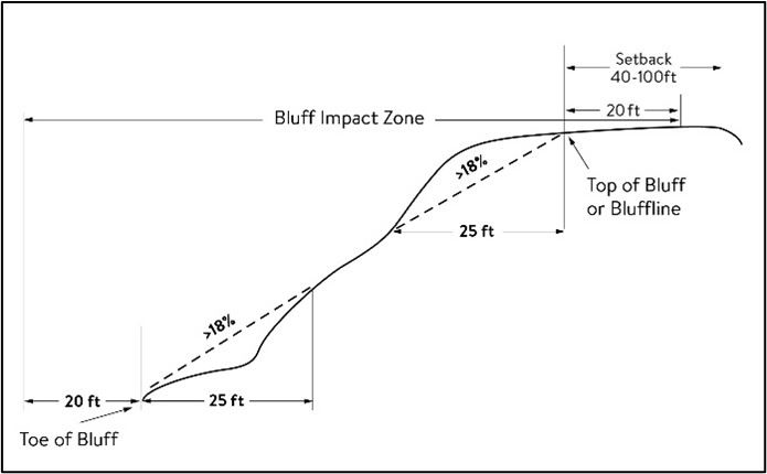
- Bluff: A natural feature with an average slope exceeding 18% with a height over 25 feet over a distance of 25 feet.
- Bluff impact zone: Area within 20 feet of the top of a bluff. This includes properties with steep slopes
- Floodplain: Located within the 100-year floodplain as mapped by FEMA (also covered by the City's Floodplain Overlay District).
- Shore impact zones: 50% of the required structure setback from the river (50 feet from the ordinary high water line of the river within the River Neighborhood district and 25 feet from the ordinary high water line of the river within the Urban Mixed district). This includes properties directly along the river.
- Native plant communities: Mapped plant communities identified by the Minnesota Biological Survey or other adopted agency
- Natural drainage route: Properties along Springbrook Creek, Stonybrook Creek, Oak Glen Creek, or Rice Creek
- Significant existing vegetation stands: Largely intact and connected plant communities along the river or natural drainage ways. This includes vegetated areas in along the river, and along Riverview Heights Park.
- Water quality impact zone: Within 50 feet of the river, Natural drainage route, or wetland
- Wetlands: Transitional areas between terrestrial and aquatic systems having the meaning given under M.S. 103G.005.
A map of where these primary conservation areas are expected can be found via a Minnesota Department of Natural Resources online map. Bluffs and blufflines may need to be verified using survey data.
Questions
If you have questions about the MRCCA, please call 763-572-3594 or email Environmental Planner Rachel.Workin@FridleyMN.gov.